BUTSER HILL
Distance: 11.6 miles
Start/finish: Buriton village centre, GU31 5RT
Terrain: Downland trail, track, road
Toughness: Moderate
Ascent: 464 metres
Navigation: Easy (waymarked)
Good for: Wildlife, ascents, national trail
Route info: wildrunning.net/42
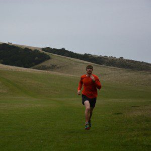
Another iconic section of the South Downs Way with wonderful running over the rolling terrain of the downs’ chalk ridge. Butser Hill, home to the infamous Butser Hill race, is the highest point on the main ridge of the South Downs. From the duck pond in Buriton, follow footpath up through Buriton Chalk Pit Nature Reserve. At road crossing, head straight up hill on track. Go under the A3 and up grassy slope to the summit of Butser Hill. Follow Limekiln Lane SW and join the South Downs Way. Follow waymarkers over Tegdown Hill, Hyden Hill and Wether Down, returning by the same route. The route passes through Queen Elizabeth Country Park, with its 20 miles of trails for exploring, café and lush woodland.
Miles Directions
0.0 From village centre follow footpaths along the Shipwrights Way south-west
0.2 Head through Buriton Chalk Pit Nature Reserve
0.4 Cross road to join the South Downs Way (SDW), heading south-west
2.3 Go under A3 and through Visitor Centre car park, continuing north-west
3.1 Leave SDW, heading north-east to reach viewpoint at summit of Butser Hill
3.4 Head south-west from summit, returning to SDW and continue south-west
4.2 Continue to follow SDW, turning left on lane and following to junction
4.6 Follow track west over Tegdown Hill and Hyden Hill to reach Droxford Road
5.8 Follow waymarkers, turning right at mast to ascend Wether Down. Return to start.
For more information on the UK’s best wild runs, buy a copy of Wild Running: 150 adventures on the trail and fells of Britain (Wild Things Publishing). For details, visit wildrunning.net

